Glass slide of town planning design for Canberra
https://nginx-develop-nfsa2.govcms7.amazee.io/sites/default/files/collection/hero_image09-2019/capital-designs_1600x775.jpg

Canberra Glass Slides

Walter Scott Griffiths' Glass Slides with Alternative Plans for Canberra

A Competing Design for Canberra

These 24 glass slides show detailed plans of an alternative design for the city of Canberra.

They are by Walter Scott Griffiths, who entered the Federal Capital City Design Competition in 1911 in a joint entry with Robert Charles Coulter and Charles Henry Caswell.

While the judging panel awarded them fourth place and accepted Walter Burley Griffin's proposal, the government purchased the Griffiths, Coulter and Caswell design and adopted their plan for drainage and sewerage.

Griffiths maintained his passionate interest in the design and construction of Canberra and over the years he further developed his vision of Australia’s capital city.

On several occasions in 1916 and 1922, he gave illustrated lectures on this alternative vision. His voice was one of many at the time commenting and responding to Walter Burley Griffin’s proposed plan for Canberra.

His presentation included the set of 24 glass lantern slides featured in this curated collection, which are now preserved at the NFSA.
Glass slide of Walter Burley Griffin's Preliminary Plan of 1913 with his proposal for roads, water features and land use for the central area of Canberra.
https://nginx-develop-nfsa2.govcms7.amazee.io/sites/default/files/09-2019/1585331_0.jpg
Walter Burley Griffin's preliminary plan
NFSA-ID:
NFSA ID
1585331
Year:
Year

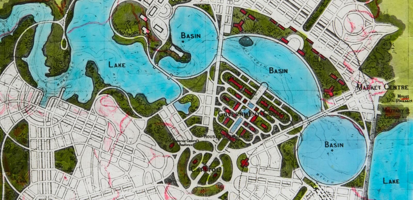
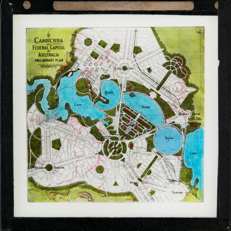
This slide shows Walter Burley Griffin's Preliminary Plan of 1913 with his proposal for roads, water features and land use for the central area of Canberra.

This was his response to the Departmental Board Plan released in 1912, which disregarded many elements of Burley Griffin’s design, even though it was the winning entry in the Federal Capital City Design Competition.

In this slide we see that Burley Griffin envisaged the lake being comprised of three basins – the West, Central and East Basins – which would have formal geometric borders.

Flanking these three basins would be two lakes – the Western and Eastern lakes – which would have shorelines that followed the natural contours of the landscape. The red lines on the slide are contour lines, indicating the gradient of the site.

Glass slide of Walter Burley Griffin's schematic plan for the central area of Canberra indicates roads, rail and waterway levels.
https://nginx-develop-nfsa2.govcms7.amazee.io/sites/default/files/09-2019/1585332_0.jpg
Walter Burley Griffin's schematic plan
NFSA-ID:
NFSA ID
1585332
Year:
Year

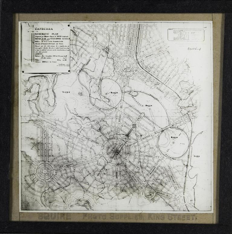
This slide shows a schematic plan for the central area of Canberra drawn up by Walter Burley Griffin in March 1915 to indicate road, rail and waterway levels.

In October 1913, Burley Griffin had been employed as the Federal Capital Director of Design and Construction by the Department of Home Affairs, to further assist with the creation and development of Canberra.

This amended plan shows some variations to his Preliminary Plan and was requested by the Minister, who was seeking plans that would enable them to proceed with the construction of Canberra.

Glass slide shows one of six sections of the painting titled 'Cycloramic view of Canberra capital site, view looking from Camp Hill'.
https://nginx-develop-nfsa2.govcms7.amazee.io/sites/default/files/09-2019/1585333_0.jpg
Section one of a painting of Canberra capital site
NFSA-ID:
NFSA ID
1585333
Year:
Year

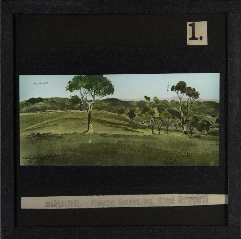
This slide shows one of six sections of the painting titled Cycloramic View of Canberra Capital Site, View Looking from Camp Hill, created by Robert Charles Coulter on 2 January 1911.

Areas shown in this slide are Narrabundah and Mount Coree. The artist’s signature is visible in the bottom left corner.

This painting was one of two, painted by Coulter, which were included in the 725 Federal Capital City Design Competition kits that were sent around the world to competition entrants.

Robert Charles Coulter, together with Charles Caswell and Walter Scott Griffiths, submitted an entry to the Federal Capital City Design Competition and were the only Australians to reach the final stages.

Many Australian architects had boycotted the competition in accordance with the wishes of the Royal Institute of British Architects, who had concerns about the way the architectural competition was being run.

Glass slide shows the second of six sections of the painting titled 'Cycloramic view of Canberra capital site, view looking from Camp Hill'.
https://nginx-develop-nfsa2.govcms7.amazee.io/sites/default/files/09-2019/1585334_0.jpg
Section two of a painting of Canberra capital site
NFSA-ID:
NFSA ID
1585334
Year:
Year

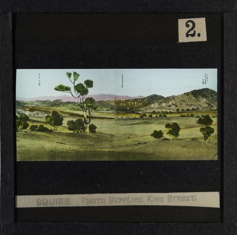
This slide shows the second of six sections of the painting titled Cycloramic View of Canberra Capital Site, View Looking from Camp Hill, created by Robert Charles Coulter on 2 January 1911.

This painting was one of two, painted by Coulter, which were included in the Federal Capital City Design Competition kits. To make copies of the original painting to include in the design competition kits, the watercolour painting would have been reproduced using lithography.

To produce these glass slides, the lithograph would have been photographed and sections of the painting printed on the glass slides. The slides were then hand-coloured by the employees of Squire Photo Supplies, Sydney.

Areas shown in this slide are West Camp, Yarralumla and Black Mountain. There are houses and a ploughed field visible in the centre of the slide, with dead trees on the hills behind them.

Glass slide shows the third of six sections of the painting titled 'Cycloramic view of Canberra capital site, view looking from Camp Hill'.
https://nginx-develop-nfsa2.govcms7.amazee.io/sites/default/files/09-2019/1585335_0.jpg
Section three of a painting of Canberra capital site
NFSA-ID:
NFSA ID
1585335
Year:
Year

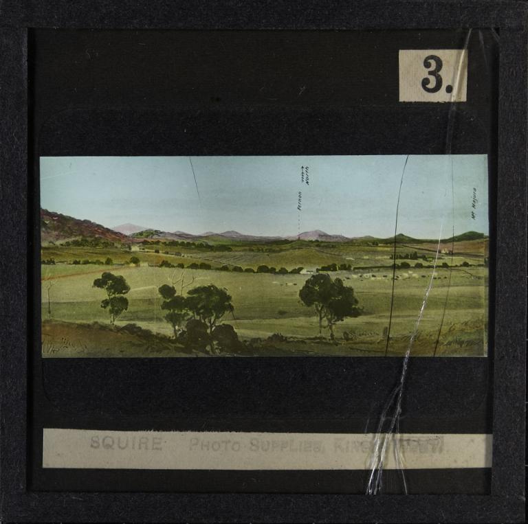
This slide shows the third of six sections of the painting titled Cycloramic View of Canberra Capital Site, View Looking from Camp Hill, created by Robert Charles Coulter on 2 January 1911.

Areas shown in this slide are Acton Homestead, Vernon and Mount Majura.

Up until the 1960s, most glass slides were produced in monochrome, with chemical dyes painted in thin coats on the surface to colour the image. Multiple colours could be used to create an authentic representation of a landscape.

Glass slides are very fragile items. Visible on this one is a crack which has occurred sometime during its long life, possibly from being dropped or roughly handled.

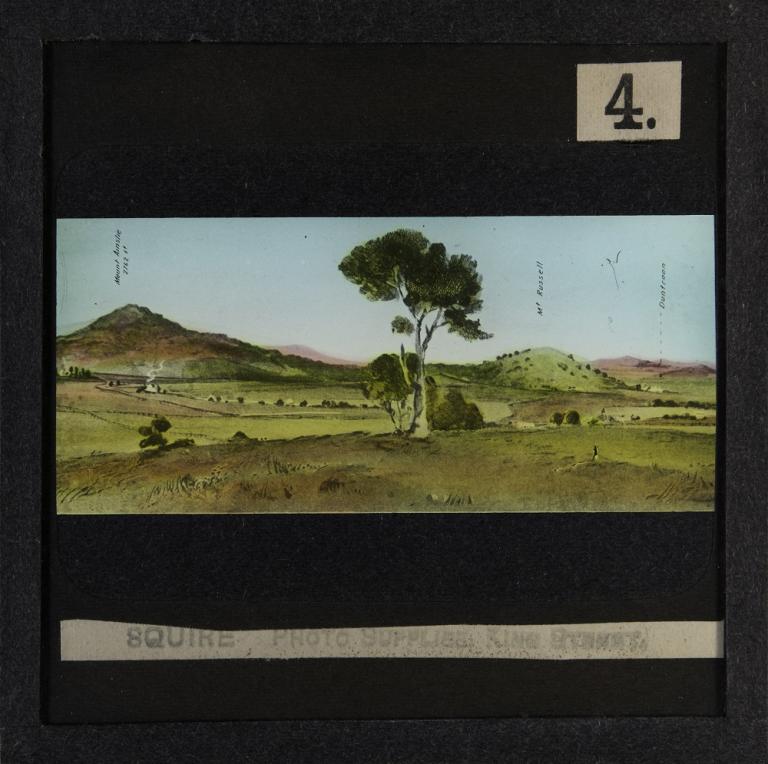
Glass slide shows the fourth of six sections of the painting titled 'Cycloramic view of Canberra capital site, view looking from Camp Hill'.
https://nginx-develop-nfsa2.govcms7.amazee.io/sites/default/files/09-2019/1585336_0.jpg
Section four of a painting of Canberra capital site
NFSA-ID:
NFSA ID
1585336
Year:
Year

This slide shows the fourth of six sections of the painting titled Cycloramic View of Canberra Capital Site, View Looking from Camp Hill, created by Robert Charles Coulter on 2 January 1911.

Areas shown in this slide are Mount Ainslie, Mount Russell and Duntroon Homestead Military College.

There is smoke coming from the chimney of a homestead on the left-hand side of the slide, and the height of Mount Ainslie is indicated as being 2,762 feet.

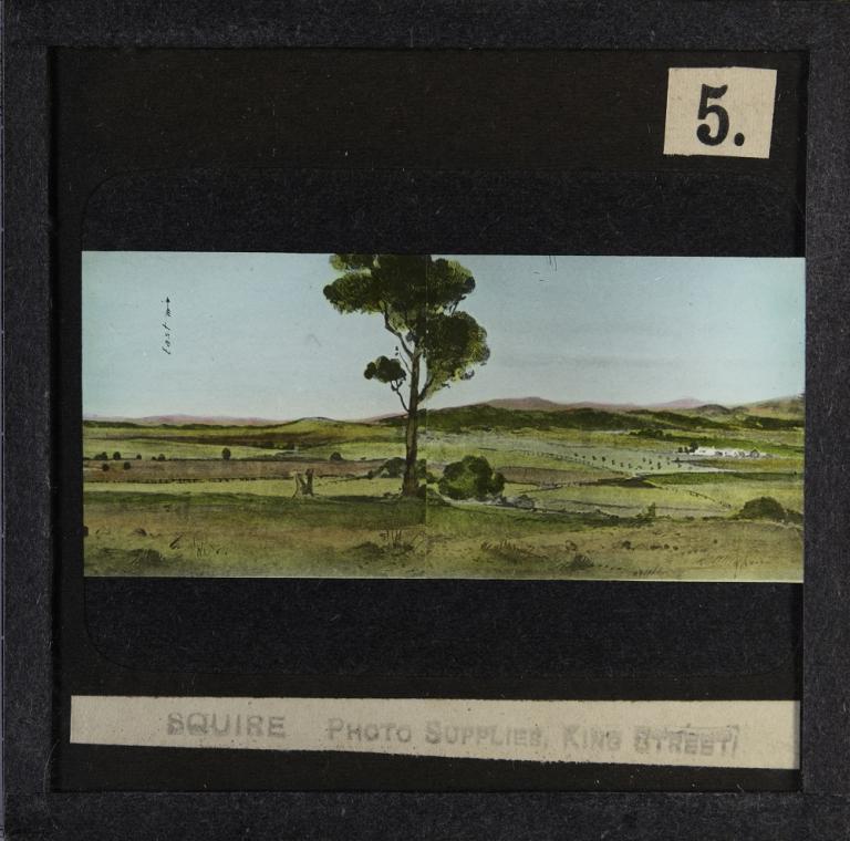
Glass slide shows the fifth of six sections of the painting titled 'Cycloramic view of Canberra capital site, view looking from Camp Hill'.
https://nginx-develop-nfsa2.govcms7.amazee.io/sites/default/files/09-2019/1585337_0.jpg
Section five of a painting of Canberra capital site
NFSA-ID:
NFSA ID
1585337
Year:
Year

This slide shows the fifth of six sections of the painting titled Cycloramic View of Canberra Capital Site, View Looking from Camp Hill, created by Robert Charles Coulter on 2 January 1911.

Visible on this slide is the Duntroon Homestead on the right, with fenced fields stretching across the slide.

As with the other five slides showing sections of this landscape painting, it was possibly created earlier than the other slides in this curated collection.

These six painting slides have black borders around the image and are numbered 1-6 in the top right-hand corner, despite being slides 3–9 in the presentation given by Walter Scott Griffiths.

This slide was professionally painted by Squire Photo Supplies, Sydney. 

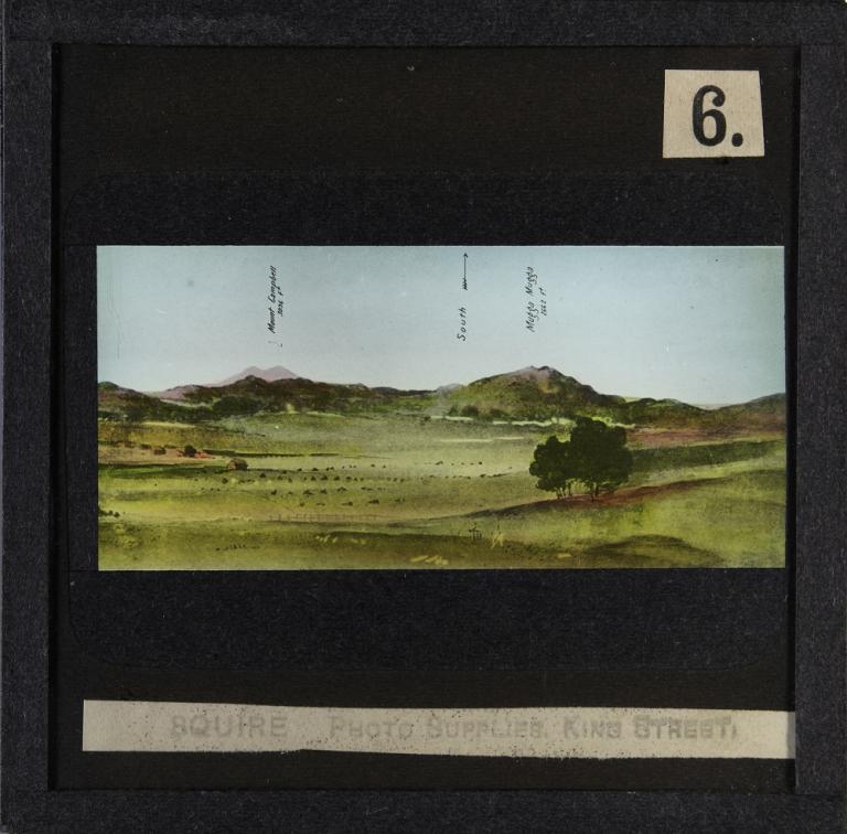
Glass slide shows the sixth of six sections of the painting titled 'Cycloramic view of Canberra capital site, view looking from Camp Hill'.
https://nginx-develop-nfsa2.govcms7.amazee.io/sites/default/files/09-2019/1585338_0.jpg
Section six of a painting of Canberra capital site
NFSA-ID:
NFSA ID
1585338
Year:
Year

This slide shows the sixth of six sections of the painting titled Cycloramic View of Canberra Capital Site, View Looking from Camp Hill, created by Robert Charles Coulter on 2 January 1911.

Areas shown in this slide are Mount Campbell, which is indicated as being 3,096 feet high, and Mount Mugga Mugga, which is 2,662 feet high.

Walter Scott Griffiths included these images in his presentation to demonstrate the natural beauty of the area but also to show that a lot of excavation would be needed to create Walter Burley Griffin’s design for Canberra, because it was such an undulating landscape.

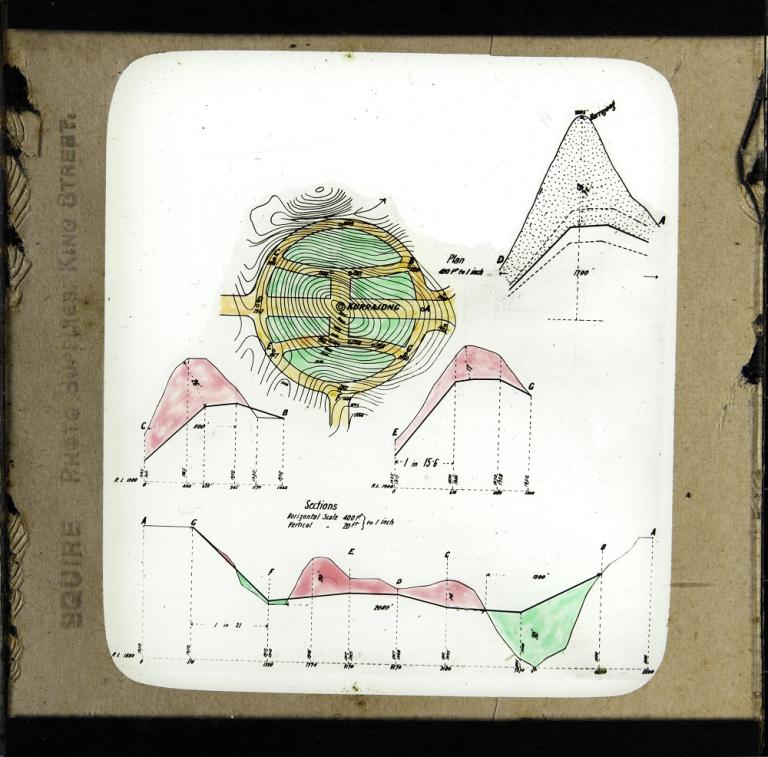
Glass slide showing a plan and four section drawings of the roadworks planned for the inner circuit of Kurrajong Hill as proposed by Walter Burley Griffin.
https://nginx-develop-nfsa2.govcms7.amazee.io/sites/default/files/09-2019/1585339_0.jpg
Inner circuit of Kurrajong Hill
NFSA-ID:
NFSA ID
1585339
Year:
Year

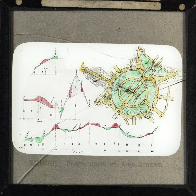
This slide shows a plan and four section drawings of the roadworks planned for the inner circuit of Kurrajong Hill, as proposed by Walter Burley Griffin.

This area is now known as Capital Hill and is where the Australian Parliament House now sits.

At this time Kurrajong Hill was a large hill and the steepness of the site is evident from the section drawings and the contour lines on the plan.

Walter Burley Griffin had proposed putting a grand building, which he referred to as the ‘Capitol’, on Kurrajong Hill. This was to take advantage of the views across Canberra that were visible from the hill.

Glass slide showing a plan and three section drawings of roads for the wider area of the circuit around Kurrajong Hill, as proposed by Walter Burley Griffin.
https://nginx-develop-nfsa2.govcms7.amazee.io/sites/default/files/09-2019/1585340_0.jpg
Outer Circuit of Kurrajong Hill
NFSA-ID:
NFSA ID
1585340
Year:
Year

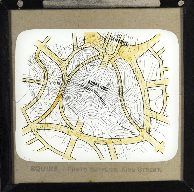
This slide shows a plan and three section drawings of roads for the wider area of the circuit around Kurrajong Hill, as proposed by Walter Burley Griffin.

On the upper right-hand side of the slide, Camp Hill is visible.

The contour lines on the plan, as well as the measurements on the section drawings, reveal that this site was steep and hilly.

Walter Scott Griffiths wanted to show that Burley Griffin’s plan to build roads that cut through Kurrajong Hill would necessitate a lot of excavation on that site.

Glass slide showing an alternative design proposed by Walter Scott Griffiths for Kurrajong Hill. Griffith's plan is overlaid onto Walter Burley Griffin's plan for the Hill
https://nginx-develop-nfsa2.govcms7.amazee.io/sites/default/files/09-2019/1585341_0.jpg
Alternative Design for Kurrajong Hill
NFSA-ID:
NFSA ID
1585341
Year:
Year

This slide shows an alternative design proposed by Walter Scott Griffiths for Kurrajong Hill.

Griffiths' plan is overlaid onto Walter Burley Griffin's plan for Kurrajong Hill, the outline of which are visible on this slide. Contour lines on the plan indicate the steepness of the site.

The use of 'Kurrajong Hill' dates the creation of this slide to sometime before 1920 which is when Kurrajong Hill was renamed Capitol Hill. It later became Capital Hill, its current name.

Walter Scott Griffiths' alternative proposal – to build the road around what was almost the base of Kurrajong Hill, rather than through its centre – was designed to limit the amount of excavation required to create the roads.

Glass slide showing a plan and seven section drawings for the area now known as the Parliamentary Triangle, which is situated between the Central Basin and Camp Hill.
https://nginx-develop-nfsa2.govcms7.amazee.io/sites/default/files/09-2019/1585342_0.jpg
Government Centre
NFSA-ID:
NFSA ID
1585342
Year:
Year

This slide shows a plan and seven section drawings for the area now known as the Parliamentary Triangle, which is situated between the Central Basin and Camp Hill.

Walter Burley Griffin called this precinct the 'Government Group', and envisaged it being filled with government departments including Trade and Customs, Home Affairs, Treasury, Defence and the Postmaster General.

The contour lines on the map indicate the gradient of the area and this is also represented in the section drawings. A water feature is visible running down the centre of the site.

The letters on the map from 'A' to 'U' indicate particular areas on the site and are also used on the section drawings. The word 'schistose' appears twice on this slide and refers to the metamorphic rocks found in this location.

Glass slide believed to show Griffiths, Coulter and Caswell's design for drainage and sewerage as per their submission to the Federal Capital design competition.
https://nginx-develop-nfsa2.govcms7.amazee.io/sites/default/files/09-2019/1585343_0.jpg
Canberra Drainage
NFSA-ID:
NFSA ID
1585343
Year:
Year

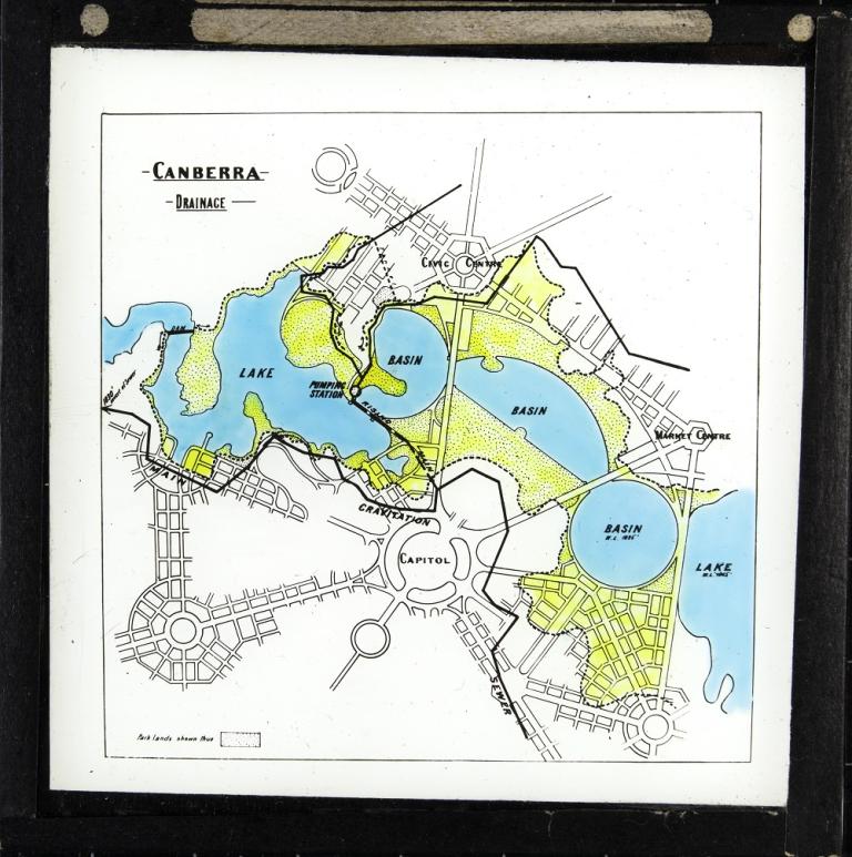
This slide shows the design of Griffiths, Coulter and Caswell for drainage and sewerage as per their submission to the Federal Capital City Design Competition.

Although they did not win the competition, their plan for drainage and sewerage was purchased and then incorporated into the design process for Canberra.

In this slide that drainage plan is overlaid on Walter Burley Griffin's Preliminary Plan. Visible are the rising main, the main gravitational sewer, pumping station and dam.

The parklands surrounding the lake are indicated by areas full of small dots. The yellow areas on the slide indicate the floodplains, the low-lying areas with the potential to flood in times of high rainfall.

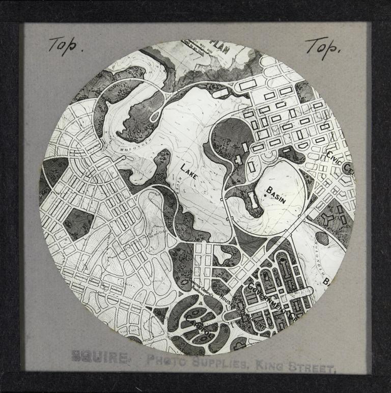
Glass slide focussing on the West Lake and West Basin with only half of the Central Basin visible.
https://nginx-develop-nfsa2.govcms7.amazee.io/sites/default/files/09-2019/1585344_0.jpg
Walter Burley Griffin's Preliminary Plan: West View
NFSA-ID:
NFSA ID
1585344
Year:
Year

One of three black-and-white slides showing close-ups of a section of Walter Burley Griffin's Preliminary Plan.

This slide focuses on the West Lake and West Basin with only half of the Central Basin visible.

You can see a marking for the Governor-General’s Residence, adjacent to State Circle on Capitol Hill, which is some distance from the place where it ended up being built, on the foreshore of the Molonglo River.

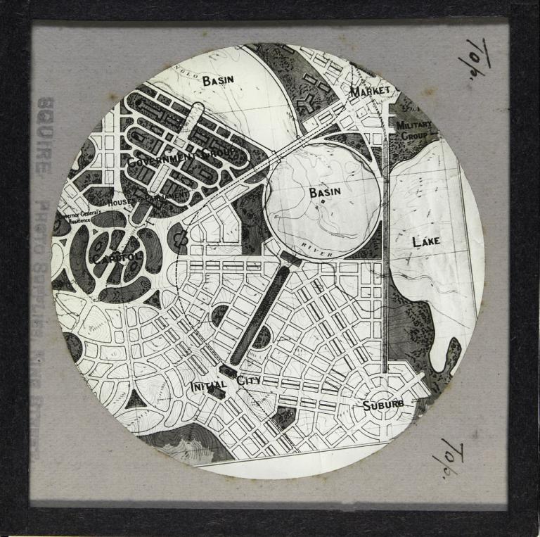
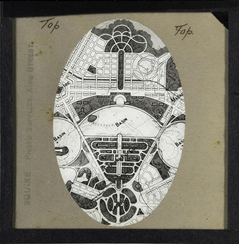
The images on these three slides are surrounded by cream-paper borders, in either a circular or oval shape. The cream-paper border is not used on any of the other slides in this series, which may indicate that they were originally used in another presentation.

Glass slide focussing on the Eastern Lake and East Basin with only half of the Central Basin visible.
https://nginx-develop-nfsa2.govcms7.amazee.io/sites/default/files/09-2019/1585345_0.jpg
Walter Burley Griffin's Preliminary Plan: East View
NFSA-ID:
NFSA ID
1585345
Year:
Year

The second of three black-and-white slides showing close-ups of a section of Walter Burley Griffin's Preliminary Plan.

This slide focuses on the Eastern Lake and East Basin with only half of the Central Basin visible.

The Eastern Lake was rejected by the committee of the Parliamentary Works Inquiry into 'Dams for Ornamental Waters – Canberra', which took place between July 1915 and November 1916.

They found that it would submerge a large area of land and be too expensive to construct, and that the Eastern Lake Causeway would be unsightly.

Glass slide focussing on the Central Basin, which Burley Griffin referred to as the Segmental Basin, with only part of the West and East Basins visible.
https://nginx-develop-nfsa2.govcms7.amazee.io/sites/default/files/09-2019/1585346_0.jpg
Walter Burley Griffin's Preliminary Plan: Central View
NFSA-ID:
NFSA ID
1585346
Year:
Year

The third of three black-and-white slides showing close-ups of a section of Walter Burley Griffin's Preliminary Plan.

This slide focuses on the Central Basin, which Burley Griffin referred to as the Segmental Basin, with only part of the West and East Basins visible.

Each of the three slides is stamped 'Squires, Photo Supplies, Sydney' and the word 'Top' is handwritten twice to indicate the top of the image.

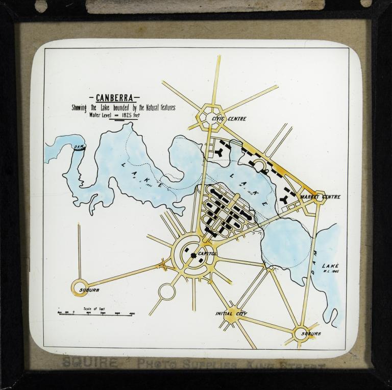
Glass slide showing a plan of what the lake would look like if it were built following the natural contours of the land.
https://nginx-develop-nfsa2.govcms7.amazee.io/sites/default/files/09-2019/1585347_0.jpg
Lake bounded by natural features
NFSA-ID:
NFSA ID
1585347
Year:
Year

This slide shows a plan of what the lake would look like if it were built following the natural contours of the land, rather than undertaking excavation and infill to create a more formal lake.

Walter Burley Griffin's design for the lake, as per his Preliminary Plan, is shown by dotted lines on this map.

The water level for the West and Central Basin is shown as being 1,825 feet whereas the level for the Eastern Lake is 1,845 feet.

In this slide, the Central Basin is an unusual shape and quite different to the semi-circle feature that was proposed by Walter Burley Griffin.
https://nginx-develop-nfsa2.govcms7.amazee.io/sites/default/files/09-2019/1585348_0.jpg
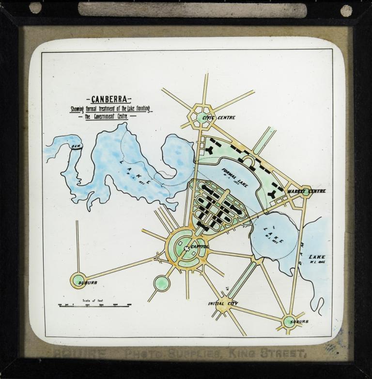
Formal treatment of lake fronting Government Centre
NFSA-ID:
NFSA ID
1585348
Year:
Year

The lake in this slide is the same shape as the previous slide, to be created by following the natural contours of the land, with the exception of the Central Basin.

Here, the Central Basin is an unusual shape and quite different to the semi-circle feature that was proposed by Walter Burley Griffin.

The shoreline where the Central Basin intersects with the Government Centre is not a straight line, as per Walter Burley Griffin's plan; instead, the two upper-most corners of what is now known as the Parliamentary Triangle are submerged.

By more closely following the natural contours in this area, Walter Scott Griffiths hoped to minimise the amount of excavation and infill needed to construct the lake, whilst still creating a Central Basin that had a formal rather than irregular shape.

Burley Griffin's design for the lake, from his Preliminary Plan, is shown by dotted lines on this map.

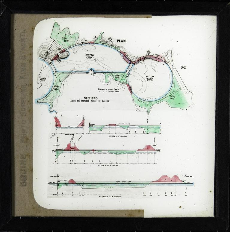
Glass slide showing a plan and three section drawings for the proposed basin walls for the lake, as per Walter Burley Griffin's Preliminary Plan.
https://nginx-develop-nfsa2.govcms7.amazee.io/sites/default/files/09-2019/1585349_0.jpg
Proposed walls for basins
NFSA-ID:
NFSA ID
1585349
Year:
Year

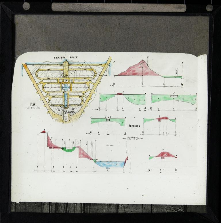
This slide shows a plan and three section drawings for the proposed basin walls for the lake, as per Walter Burley Griffin's Preliminary Plan.

On this slide, the areas that would require excavation appear in red and those requiring infill are green.

Text below the plan on the slide shows that the total area of filling would be 244 acres and the total area of cutting, 29 acres. 

When this presentation was given, there were concerns about the high cost of excavation and infill needed to create Walter Burley Griffin's proposed lake.

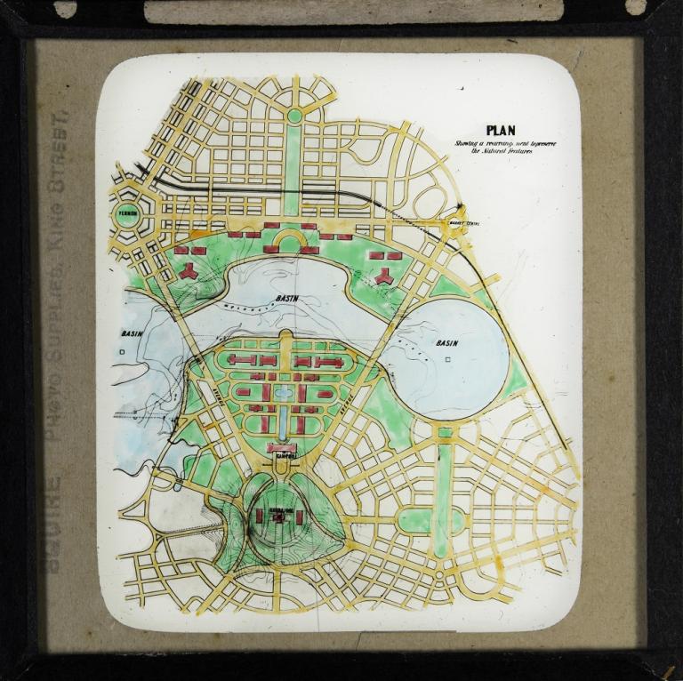
Glass slide of proposed lake showing rearrangement to preserve the natural features.
https://nginx-develop-nfsa2.govcms7.amazee.io/sites/default/files/09-2019/1585350_0.jpg
Lake rearrangement to preserve natural features
NFSA-ID:
NFSA ID
1585350
Year:
Year

In this slide, the Central Basin is an unusual shape and quite different to the semi-circle feature that was proposed by Walter Burley Griffin. The Eastern Basin appears as proposed by Burley Griffin.

By more closely following the natural contours in this area, Walter Scott Griffiths hoped to minimise the amount of excavation and infill needed to construct the lake, whilst still creating Central and Eastern Basins that had formal shapes rather than irregular ones.

The East Lake (or Eastern Lake) is not shown. Removal of the East Lake from the design was a finding of the Parliamentary Works Inquiry into 'Dams for Ornamental Waters – Canberra', which took place between July 1915 and November 1916.

This slide also contains Walter Scott Griffiths' alternative design for Kurrajong Hill, as seen in slide 11.

Burley Griffin's design for a proposed railway appears as a thick line on this map, which runs parallel to Constitution Avenue and then curves down around the edge of the Eastern Basin.

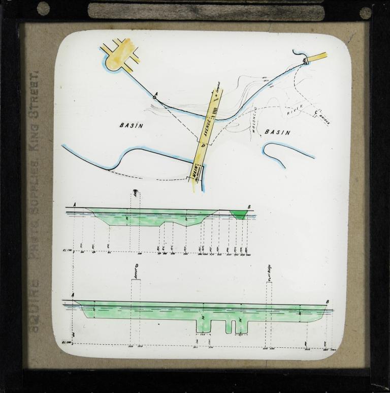
Glass slide showing a plan and two section drawings of the main avenue bridge crossing over the Central and Western Basins and the depth of lake under the bridge.
https://nginx-develop-nfsa2.govcms7.amazee.io/sites/default/files/09-2019/1585352_0.jpg
Bridge crossing between central and western basins
NFSA-ID:
NFSA ID
1585352
Year:
Year

This slide shows a plan and two section drawings of the main avenue bridge crossing over the Central and Western Basins and the depth of lake under the bridge. This bridge is now known as the Commonwealth Avenue Bridge.

The shape of the Central and Western Basins are shown as proposed by Walter Scott Griffiths, with Walter Burley Griffin's design from his Preliminary Plan indicated by dotted lines.

In this slide, Walter Scott Griffiths is demonstrating how his plan would necessitate less infill to create the Parliamentary Triangle whilst also reducing the amount of excavation needed on the opposite bank.

An additional bridge that was present in Walter Burley Griffin's Preliminary Plan, crossing over the Western Lake, is visible in the top right-hand area of the slide.

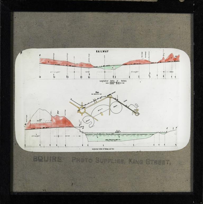
Glass slide showing a plan and two longitudinal section drawings for Walter Burley Griffin's design for the proposed railway, as shown on his Preliminary Plan.
https://nginx-develop-nfsa2.govcms7.amazee.io/sites/default/files/09-2019/1585351_0.jpg
Railway
NFSA-ID:
NFSA ID
1585351
Year:
Year

This slide shows a plan and two longitudinal section drawings for Walter Burley Griffin's design for the proposed railway, as shown on his Preliminary Plan, which was to run parallel to Constitution Avenue and then curve down between the Eastern Basin and the Eastern Lake.

On the section drawing at the bottom of the slide appears a tunnel at Market Centre and a dam, which Burley Griffin called the Eastern Lake Causeway.

This causeway would have operated as both a bridge crossing and a weir holding back the waters of the Eastern Lake, which Burley Griffin envisaged as having a water level of 1,845 feet. The remainder of the lake system was to be 1,825 feet.

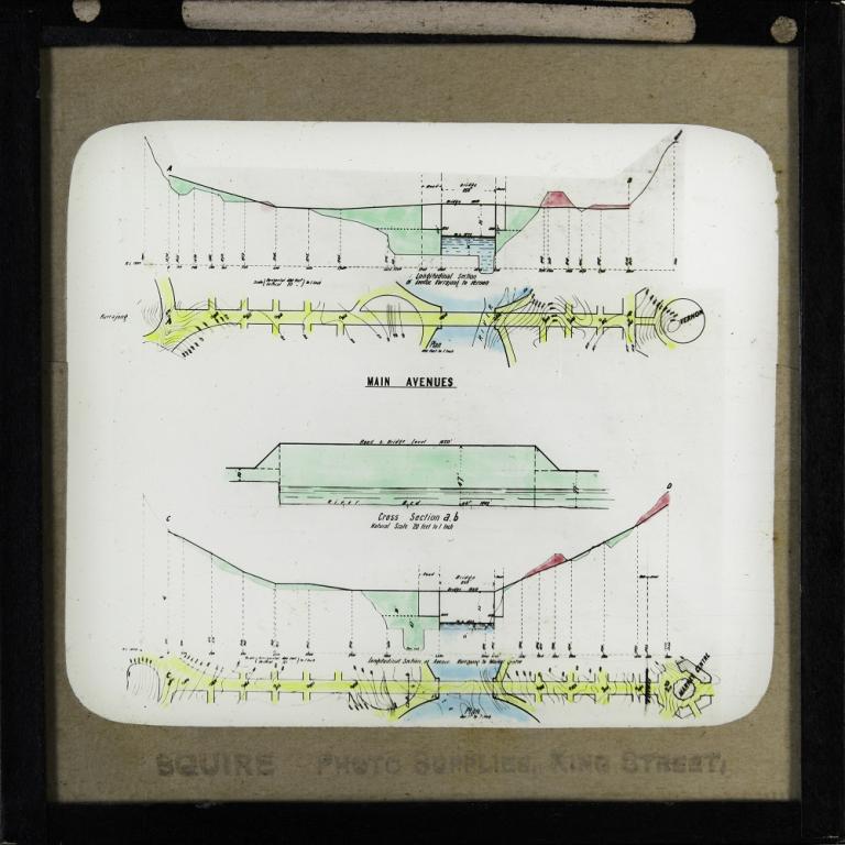
Glass slide showing two plans, two longitudinal sections and a cross section of the main avenues, now known as Commonwealth Avenue and Kings Avenue.
https://nginx-develop-nfsa2.govcms7.amazee.io/sites/default/files/09-2019/1585353_0.jpg
Main Avenues
NFSA-ID:
NFSA ID
1585353
Year:
Year

This slide shows two plans, two longitudinal sections and a cross-section of the main avenues, now known as Commonwealth Avenue and Kings Avenue, including the points where they cross over the lake.

Confusingly, on this slide both roads are referred to as ‘Avenue Kurrajong’, presumably because they intersect at Kurrajong Hill.

Originally Walter Burley Griffin had envisaged there being seven bridges, as well as an Eastern Lake Causeway and a road on top of Yarralumla Dam, crossing the lake.

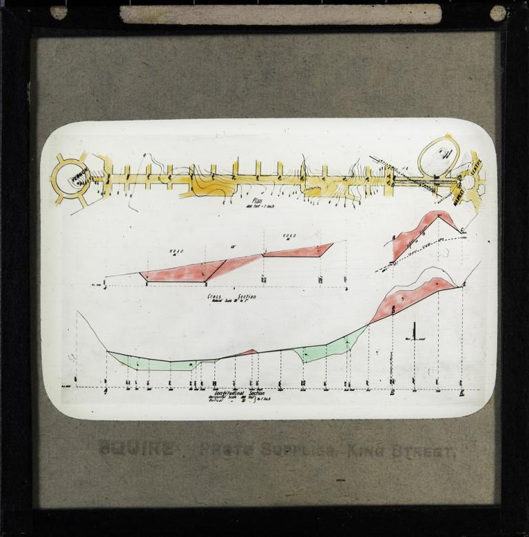
Glass slide showing a plan, two cross section drawings and a longitudinal section drawing of the road between Vernon, which Walter Burley Griffin also called the Civic Centre, and Market Centre, which is now the suburb of Russell.
https://nginx-develop-nfsa2.govcms7.amazee.io/sites/default/files/09-2019/1585354_0.jpg
Road between Vernon and Market centre
NFSA-ID:
NFSA ID
1585354
Year:
Year

This slide shows a plan, two cross-section drawings and a longitudinal section drawing of the road between Vernon, which Walter Burley Griffin also called the Civic Centre, and Market Centre, which is now the suburb of Russell.

Indicated on the slide are natural features in the area such as granite boulders and watercourses.

The proposed railway tunnel that was to cross under the road now known as Constitution Avenue is indicated by a diagonal dotted line in the top right-hand corner of the slide.

Some Canberra residents still use the name ‘Civic’ when referring to the city centre of Canberra.